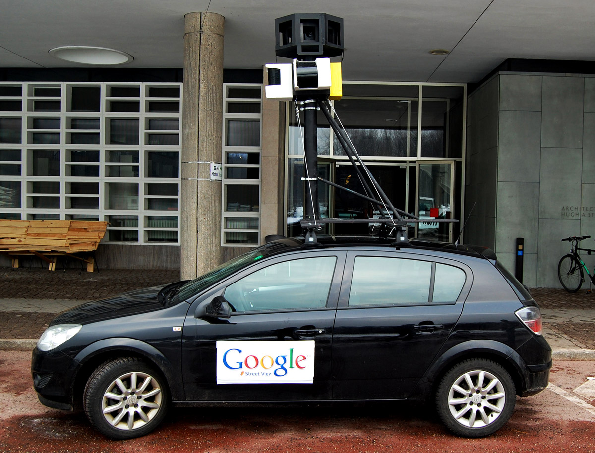
Google Street View


Shortly after a Street View tour of London’s Gatwick Airport, Google has expanded its transit program to encompass 15 other airports, more than 50 train & metro stations – and even allows your virtual trips to take you right onto an airliner at Dubhai.
Google’s blog shows off a small selection of the new locations, including check-in at Madrid airport, arrivals at Tokyo airport, a walk though London’s Waterloo train station and locating your seat on board an Emirates A380 airliner.
The split view, showing both terminal map and Street View walk-thru, is particularly helpful for familiarising yourself with a transit airport in advance of a tight connection …
Expand
Expanding
Close
I sometimes wonder whether future generations will do most of their travel sat at their PCs, as Google’s Trekker backpack takes us to more and more interesting places. Latest on the list is the romantic Italian city Venice, built on a set of more than 100 small islands, connected by a network of canals and bridges …
Expand
Expanding
Close

Not sure I’ve ever seen it quite this empty …
Finding your way around large airport terminals can be one of life’s more frustrating experiences, especially when you’re in a hurry and for no reason any human being can understand, gates 22-24 are not between gates 21 and 25.
Google is helping lost travellers find their way around London’s second-largest airport, with full Street View imagery of both North and South terminals.
Take your virtual visit here.
Other Street View tours created with Google’s Trekker backpack includes the River Thames, the world’s tallest skyscraper, the Eiffel Tower, a Bond villain’s lair, a trek up to the top of Mount Fuji , animal park tours, a look around the inside of Dr Who’s TARDIS, CERN’s Large Hadron Collider and a submarine.


Google just announced a few updates rolling out to the new Google Maps desktop app today. Users will now be able to highlight StreetView imagery, user-uploaded photos, and PhotoSpheres on the map by clicking a new pegman icon in the lower right corner of their screen (pictured above). StreetView imagery will be highlighted in light blue, Photo Spheres as darker blue circles, and indoor imagery as yellow circles.
In addition, the update brings a touch of Google Earth over to the Maps desktop app with new bird’s-eye view 3D Earth Tours for all WebGL-enabled browsers.
Explore beautiful, 3D imagery of buildings and terrain for thousands of locations from above with Earth Tours available right in your browser.* Wherever you see the Earth Tour icon, you can click, sit back, and get a virtual tour from a soaring angle. Dive into Boston or circle the Alps.

Google is also rolling out a new preview UI for directions. Now, when viewing individual steps for directions you’ll see StreetView imagery on each step where available, allowing you to get a better sense of your surroundings for an upcoming turn or exit. Google also notes that it has integrated real time traffic incident reports from its Waze acquisition like it recently did in its mobile Google Maps apps.
The new Google Maps desktop app is rolling out to all that opted into the new Google Maps preview today and to everyone else in teh coming weeks. Google also just released a video preview for the new Google Maps desktop experience that shows off some of the new features in today’s update:
Expand
Expanding
Close
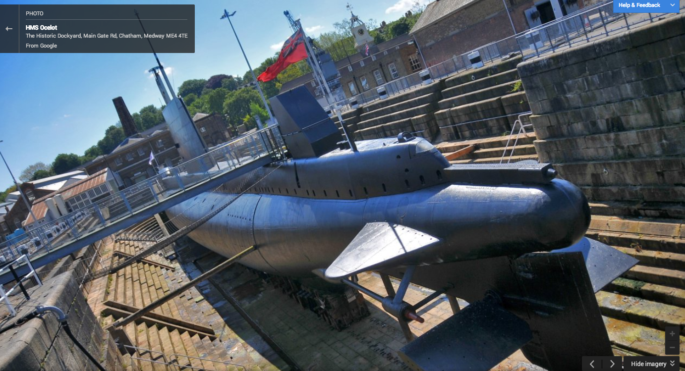
The HMS Ocelot, a 50-year-old British submarine has the distinct honor of being the first submersible to be offered up on Google’s street view. The Register reports the company mapped-out the control room, sleeping quarters and even some of the torpedo tubes, which are obviously out of service. There’s also a tour of the dockyard which launched the submarine and a set of 20 images of the exterior of the boat. I mean, this is a freaking submarine on Google street view, does it really get any better? Well, I suppose you might get more of a kick out of the Large Hadron Collider if you’re into that sort of thing, but for me, it’s a freaking submarine!
You can view the whole collection of images here.
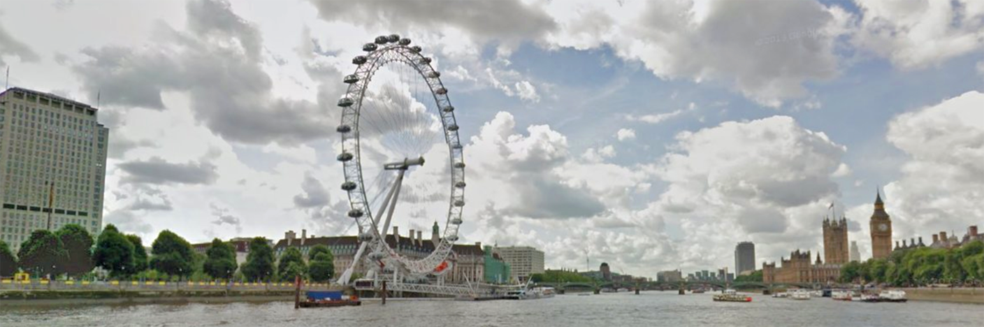
Google’s ever-expanding set of virtual tours now include a boat trip down the River Thames in London, allowing many of London’s most famous sights to be seen from a new perspective, reports the Telegraph.
Ed Parsons, Geospatial technologist at Google UK, said: “The river also offers some of the most scenic and iconic views of London from arguably the best vantage points the city has to offer, and we are thrilled to be able to work with the PLA so that users from around the world can experience the Thames through Street View.”
Expand
Expanding
Close

Google has been adding a ton of new tours and Street View collections for locations around the world in recent months, and today the fruits of a recent trip to map CERN, home of the Large Hadron Collider in Geneva, have been published for all to explore.
We’re delighted that CERN opened its doors to Google Maps Street View allowing anyone, anywhere in the world to take a peek into its laboratories, control centers and its myriad underground tunnels housing cutting-edge experiments. Street View also lets scientists working on the experiments, who may be on the other side of the world, explore the equipment they’re using.
For two full weeks back in 2011, members of our Street View team from Google’s Zurich office worked with our CERN partners to capture this incredible imagery. You can check out the above experiments, like ATLAS, ALICE, CMS, LHCb and the Large Hadron Collider tunnel in Google Maps, as well as collections of other Street View imagery from amazing sites around the world
You can check out the new CERN Street View collection on the Google Maps Views website here.
We’ve previously pointed to a whole bunch of fun Street View tours – the world’s tallest skyscraper, the Eiffel Tower, a Bond villain’s lair, a trek up to the top of Mount Fuji , animal park tours, a look around the inside of Dr Who’s TARDIS, and even a story of an abandoned dog discovered on Google Maps.
An abandoned dog spotted outside an abandoned building in LA on Google Street View has been rescued after a local rescue centre was alerted, reports UK newspaper Metro.
Jennifer Velasquez contacted the Los Angeles-based group Hope For Paws and told them where she had seen the dog. Luckily the lost-looking canine had not moved from outside the abandoned building – where Hope For Paws’ employee Eldad Hagar found her …
Expand
Expanding
Close
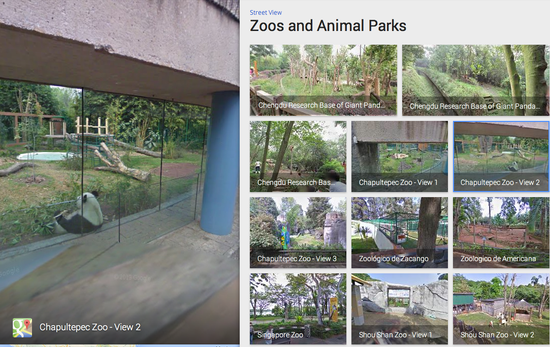
Google’s expanded Street View program today added coverage of a range of zoos and animal parks in North America, South America, Canada, Mexico, China, Germany, Spain, France, Belgium and the UK. This includes the Chengdu Research Base of Giant Panda Breeding in China, home to more than 30 percent of the world’s Giant Pandas, reports the Google Maps blog.
If you enjoy watching wildlife, but find yourself stuck in the urban jungle, never fear. You can now use Google Maps and Street View to preview the must-see spots at zoos around the world before heading there in person, or take a virtual trip to some of the most famous zoos and animal parks, right from your living room.
The development adds to a diverse range of fascinating Street View tours offered by Google in recent times …
Expand
Expanding
Close
 Google announced today on its Google Maps blog that it’s finally tapping into the talent and technology it picked up with its acquisition of Waze back in June to integrate real time incident reports from Waze into Google Maps. The new integration means that when Waze users report incidents for everything from accidents to road closures, Google Maps users on both iOS and Android will now be able to benefit:
Users of Google Maps for Mobile will now benefit from real time incident reports from Waze users. This means when Wazers report accidents, construction, road closures and more on Waze, the updates will also appear on the Google Maps app for Android and iOS.
The features will initially be limited to users in certain locations, including: Argentina, Brazil, Chile, Colombia, Ecuador, France, Germany, Mexico, Panama, Peru, Switzerland, UK and the US. In addition, as Google first hinted back in June, the company will also be integrating Google Search into the Waze apps on iOS and Android, while the Waze Map Editor now has access to Google Street View imagery:
Expand
Expanding
Close
 .
.
Sadly, there are no more secrets left to reveal here. We’d already seen the Best Buy circular and inventory system and we knew the specs which include Android 4.3 and $230-$270 price tag for 16GB and 32GB. But now you can, well, buy them. People should start getting them before the end of the month. Unless they come sooner.
Here’s Best buy’s spec list:
Enjoy your media on the go with this Google Nexus 7 tablet, which features a 7″ 10-finger capacitive touch screen with IPS technology that simplifies navigation and delivers vibrant images. Wi-Fi makes it easy to surf the Web.
Here’s the gallery from Best Buy:


It is showing up also at PC connection
Also, Droid-Life notes that it’s at Sam’s Club too.
Expand
Expanding
Close
On the same day that Google updated all its mapping products, it also demonstrated the gentle art of making a really cool piece of new technology appear deathly dull.
Today we’re announcing a new way for developers to visualize and interact with data hosted in Maps Engine: DynamicMapsEngineLayer. This class performs client-side rendering of vector data, allowing the developer to dynamically restyle the vector layer in response to user interactions like hover and click.
Sure, the blog entry is aimed at software developers, so can be forgiven its language, but the example they use to promote the feature seems more suited to a dusty geography textbook than an illustration of something that could really transform the way we use Google Maps. What it actually means is that you can mouse-over a map to really quickly and easily explore anything from tourist info to property ownership. Read on for more …
Google updated its Google Earth app for iOS and Android today with a few new features including a revamped interface that includes the left side panel it has been bringing to lots of its mobile apps.
Also new in version 7.1.1 of Earth is Google’s Street View feature, as well as improved directions and search with the ability to “visualize transit, walk, bike and drive directions in 3D while update search result list will let you browse search results quickly.” Google also announced that it is now making Google Earth available in over 100 countries worldwide:
Also with this release, we’re making Google Earth for mobile available in more than 100 countries worldwide, so you can start their virtual journey in Google Earth from almost anywhere on Earth. To unleash your inner explorer, check out your local Google Play store or iTunes to download the latest version of Earth for Android and iOS.
Version 7.1.1 of Google Earth is available on the App Store and Google Play now.
Expand
Expanding
Close
Google Street View is famous for the mapping cars, but the company also uses Trekker backpacks (seen on video here) and panoramic cameras to reach less-accessible areas of the world and to take us inside buildings. The latest building to see some Google Trekker love is the world’s tallest skyscraper, the 2,722-foot tall Burj Khalifa in Dubai …
Expand
Expanding
Close
Google’s run-ins with the law in Europe have not gone unnoticed. Earlier this week, the company was ordered to fix its privacy issues in France to avoid facing fines, and now a UK regulator is ordering the company to delete all remaining Street View data within 35 days to avoid facing criminal charges, the ICO reports. Should Google find any further data, then it must inform the ICO immediately.
Today’s enforcement notice strengthens the action already taken by our office, placing a legal requirement on Google to delete the remaining payload data identified last year within the next 35 days and immediately inform the ICO if any further disks are found. Failure to abide by the notice will be considered as contempt of court, which is a criminal offense.
Back in 2010, Google had reached an agreement with the IOC over the WiFi data its Street View cars had accidentally collected. Earlier this year, however, Google stated that had not deleted all the data the first time around, which the IOC was not pleased with. Should Google fail to delete the remaining data within the given time period, it will be hit with a criminal offense.
Expand
Expanding
Close


Google announced today on its Google Maps blog that its rolling out a ton of new Street View imagery for over 1,000 locations across Asia, Europe, Latin America, the U.S. and Canada:
Today we’re adding more than 1,000 locations around the world to Google Maps, making it more comprehensive and useful for you. From historical landmarks to sports stadiums, these panoramic photos available via Street View can help you ease into vacation mode with just a few simple clicks… you can use to preview a vacation spot, to plot your next hiking route or just to become an armchair explorer from wherever you may be.
Google highlighted a number of the new addition including new imagery for historical landmarks and more in Brazil, Singapore, Denmark, Mexico City, Chile,
You can get some of the highlights here and check out the imagery for yourself in the latest Google Maps apps for iPhone and Android.

Google for a while now has been allowing businesses in the US, Canada, UK, Australia, France, Ireland, and New Zealand hire photographers through its Business Photos program in order to capture 360-degree Street View-like imagery for the inside of retail stores and other businesses. The feature allows users to get a 360-degree, interactive tour of a business without ever leaving Google Maps. Today, Google announced it is expanding the program to seven new countries for both photographers and businesses:
Today we’re announcing the expansion of the Google Maps Business Photos program to seven new countries including: Belgium, Czech Republic, Germany, Poland, Russia, Singapore and Switzerland.
A little over a year ago Google took to Central Park in New York to capture 360-degree Street View imagery using its pedicab trike camera. Today Google is officially rolling out the new imagery to Google Maps users and is also releasing historic images of other parts of the city including the 9-11 Memorial and neighborhoods hit by Hurricane Sandy.
Imagery of Hurricane Sandy
To create a space where the New York community can share memories from before, during, and after the storm, we partnered with Historypin on a community photo and video album called Hurricane Sandy: Record, Remember, Rebuild. In the album, you can discover and contribute old and new images of the places that mean the most to you.
Tour the 9/11 Memorial
The 9/11 Memorial at the World Trade Center site is a moving tribute to those who lost their lives in the attacks on New York City, at the Pentagon and in Shanksville, PA. Panoramic images of the North and South pools allow you to see victims’ names engraved along the edges of the pools. If you aren’t able to visit lower Manhattan to pay your respects in person, let Street View be your guide to this important and moving memorial.
Explore Central Park
It’s hard to find a more beloved piece of the city than Central Park. In partnership with the Central Park Conservancy, our Street View crew went all around park collecting 360-degree imagery of its trails, paths, and plazas, to bring views of both famous and little-known areas of the park to your browser or mobile phone.

A guest post on the Google Enterprise blog today from Toyota announced that the automaker would be bringing Google technologies to its new Lexus IS model available later this year in Europe.
While it might not be Google’s self driving car tech just yet, the vehicle’s in-dash system will now provide access to Street View, Google local search, and geotagged Panoramio photos:
 The Lexus IS newest in-dash system gives users direct access to Google local search, Street View and geotagged photos from Panoramio. From cafés in Rome to museums in Paris, drivers can use their navigation system to search online for points of interest. With access to continually updated local information powered by Google, this gives Lexus users peace of mind.
We’re also excited to announce that Street View and Panoramio will be integrated in Lexus’ premium in-car technology. For the first time, Lexus drivers will be able to see real-life images of their surroundings, guiding them to nearby places.
Someone at Teehan+Lax may have grown up reading Dr. Seuss as they’ve just created a web service called Hyperlapse, allowing you to create a high-speed Street View animation of any Google Maps route.
http://vimeo.com/63653873
Expand
Expanding
Close
Google has been constantly updating its Maps and Google Earth apps with new Street View imagery in recent months. Earlier this month it began rolling out new imagery for famous mountains including Kilimanjaro and Everest, and now Google’s Street View team is hitting Northern Canada for the first time with its Street View Trekker backpacks:
This is the first Trekker expedition in Canada for Google Maps. I’m wearing the backpack to collect Street View imagery as I walk to the shore of Frobisher Bay, where the wind is the strongest and you can see the tide piling up mountains of sea ice. On the way I’ll pass sled dogs tied up outside houses, yapping in anticipation of their next trip. And I may stop to check out an igloo, built by Inuit craftsmen using methods passed down over a millennia.
Google rolled out the official YouTube app for Wii U in November, allowing users to browse channels and categories from the GamePad and view the video in 1080p on their TVs. Today, as previously announced, Google is rolling out its new Google Maps and Street View solution for Wii U owners with the Wii Street U app available now on the Wii U eShop. The app allows users to view street view and 360 degree content and easily navigate Google Maps using the Wii U GamePad:
With Wii Street Utm powered by Google, you can step into Google Street View with an immersive experience that will make you feel like you’re actually there! View a 360 degree Google Maps Street View of locations all over the world using the Wii Utm GamePad controller’s motion controls. Jumping to a location is easy—just use the GamePad touch screen to type in an address or location and start exploring, or instantly travel to over 70 fascinating, hand-picked locations around the globe.
A video of the app in action is below:
Expand
Expanding
Close

While still taking its sweet time building a Maps app for iOS, Google is making sure to take care of its own business today by launching the biggest update ever for Street View.
Street View is a five-year-old feature in Google Maps and Google Earth that provides panoramic views of many streets in the world, and its latest update adds over 250,000 miles of roads from around the globe. Google’s Street View team elaborated on the service’s expansion in a post on the official Lat Long blog:
We’re increasing Street View coverage in Macau, Singapore, Sweden, the U.S., Thailand, Taiwan, Italy, Great Britain, Denmark, Norway and Canada. And we’re launching special collections in South Africa, Japan, Spain, France, Brazil and Mexico, among others.
[youtube=http://www.youtube.com/watch?v=kMWxBpM-MSA&feature=youtu.be]
Google has been working with businesses to get panoramic Street View-style imagery for quiet a while to essentially provide Google Maps users with the ability to browse the inside of retail stores and other buildings. Today, Google is rolling out some improvements to the feature including an easier way to access the 360-degree imagery. Now, when browsing Google Maps, you can drag the orange Pegman onto any orange circle (which indicate a location with interior imagery) to zoom right into the building:
Now, if you’re searching or browsing Google Maps and want to check out what a business looks like on the inside, we’ve improved your ability to find and view these 360-degree panoramics. Simply drag and drop the orange Pegman on the left hand side of your screen onto an orange circle on the map. Voila! You’ll be virtually transported through the doors, and able to pan around and explore the interior of the establishment.
Google also posted the video above showing off where to find some of these interior business photos.