Google Street View


Google is preparing to shut down the dedicated Street View app on Android, keeping the feature in Google Maps.
Expand Expanding Close
To mark the 15th anniversary of Street View, Google Maps is rolling out a slew of features including the ability to view historical data on Android and iOS, as well as a new camera system.
Expand Expanding Close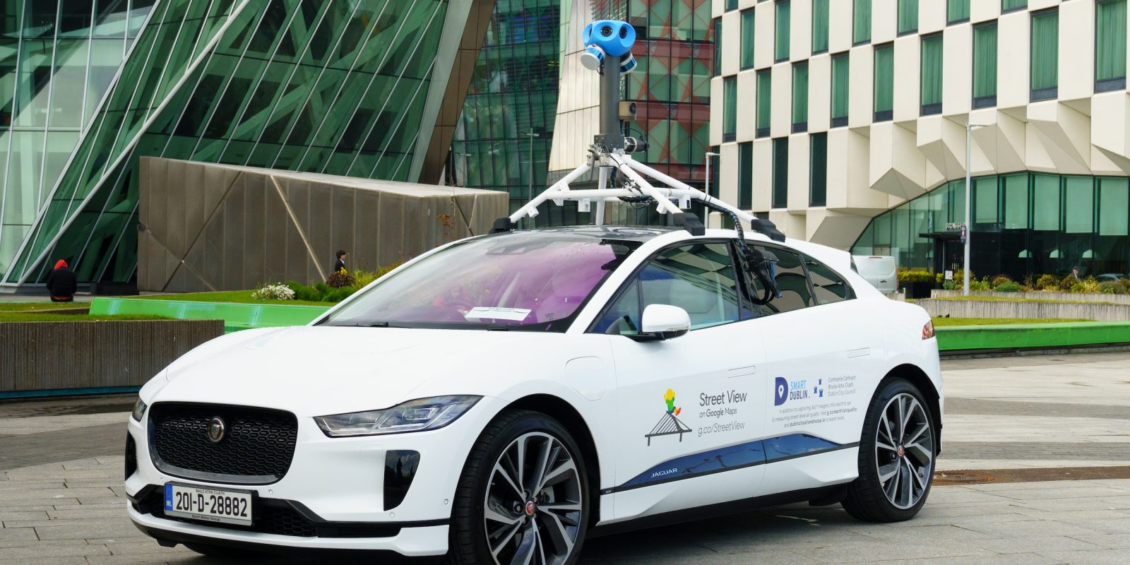
For the past few years, Google has equipped its mapping vehicles with air pollution sensors. Google worked with Jaguar Land Rover on the first all-electric Street View car that will be tasked with measuring air quality in Dublin, Ireland.
Expand Expanding Close
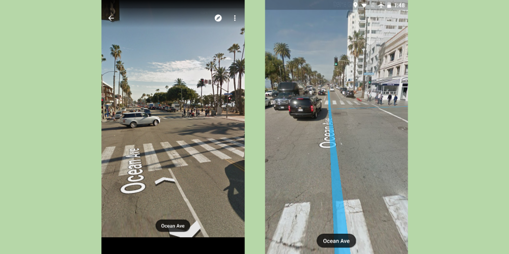
Street View launched over a decade ago, and this vast image database is currently powering the Live View AR feature. An update to Google Maps for Android improves the Street View experience by adding a split screen mode.
Expand Expanding Close
The Inauguration of Joe Biden and Kamala Harris was always going to be a momentous occasion, but it saw the unexpected creation of a truly delightful meme involving Senator Bernie Sanders sitting down. A fun meme generator, powered by Google Maps Street View, lets you have Bernie Sit down anywhere in the world.
Expand Expanding Close
Google has upgraded its Street View app on Android to allow you to capture and submit your own Street View photos with nothing more than your phone.
Expand Expanding Close
Google Maps and Earth are two useful pieces of software for getting around or learning more about our planet, and this week, Google is offering up some details on just what percentage of the planet these two services have mapped.
In addition to being a fun way to explore landmarks, Street View is useful for getting a detailed sense of where you’re going. Google Maps on the web has long provided a more useful Street View experience, but the Android app was just updated to match.
Google is settling in a lawsuit from 2010 regarding its Street View program after private data was obtained over Wi-Fi by the company’s Street View vehicles over the course of three years.
In 2017, Google introduced the first major upgrade to Street View cars in eight years aimed at capturing higher-resolution images. The Google Maps team is now slimming down the Street View Trekker backpack used for capturing 3D imagery on the go.

Google StreetView cars will soon be used to create maps of air pollution in London. They previously did the same in San Francisco, Los Angeles, and the Central Valley regions of California …
Street View within Google Maps has always been a fun and easy way to virtually walk through the streets of different cities and towns. Now, Google has sent a camera crew into Disneyland and Disney World to capture the magic found within 11 Disney Parks…
Back in September, Google Street View vehicles received their first major upgrade in eight years that should result in high-resolution images. Today, Google Research detailed a new algorithm that should address a common flaw with current Street View panoramas.
Back in 2015, Google announced a project to equip its Street View cars with air pollution sensors from Aclima to map air quality. Focussing on San Francisco, Los Angeles, and the Central Valley regions of California, the company today announced those results.
Google revealed today that the Street View cameras that sit atop the roofs of vehicles that roam and catalogue the world have received a quality bump. While this results in higher resolution images, it also means better data for its image recognition systems.
Google’s Street View cars are pretty well known and iconic for their role in developing Google Maps, and quite a lot of those cars are based off of the Subaru Impreza. Now, a model car fan has developed a scale model of Google’s vehicle, with a fun little twist.
Google has been working hard to capture remote landscapes that most people won’t ever be able to see in person, including a volcano. Street View’s latest adventure takes the viewer off of planet Earth and into the International Space Station (ISS)…
Google Street View is great for exploring an area from the comfort of your sofa, but if you want some more inspirational images to see how great a place can look, you probably seek out some better-quality photos. You may not have to do that for long thanks to a machine-learning project Google is running.
Google fed an experimental deep learning system a supply of professional photos from which to learn, then had it try its hand at emulating these from a set of around 40,000 plain old Street View snaps …
Google Search is now better at understanding art and surfacing relevant information. In partnership with the Arts & Culture team, there is a new interactive Knowledge Panel, while Street View in museums is using machine learning to recognize paintings.
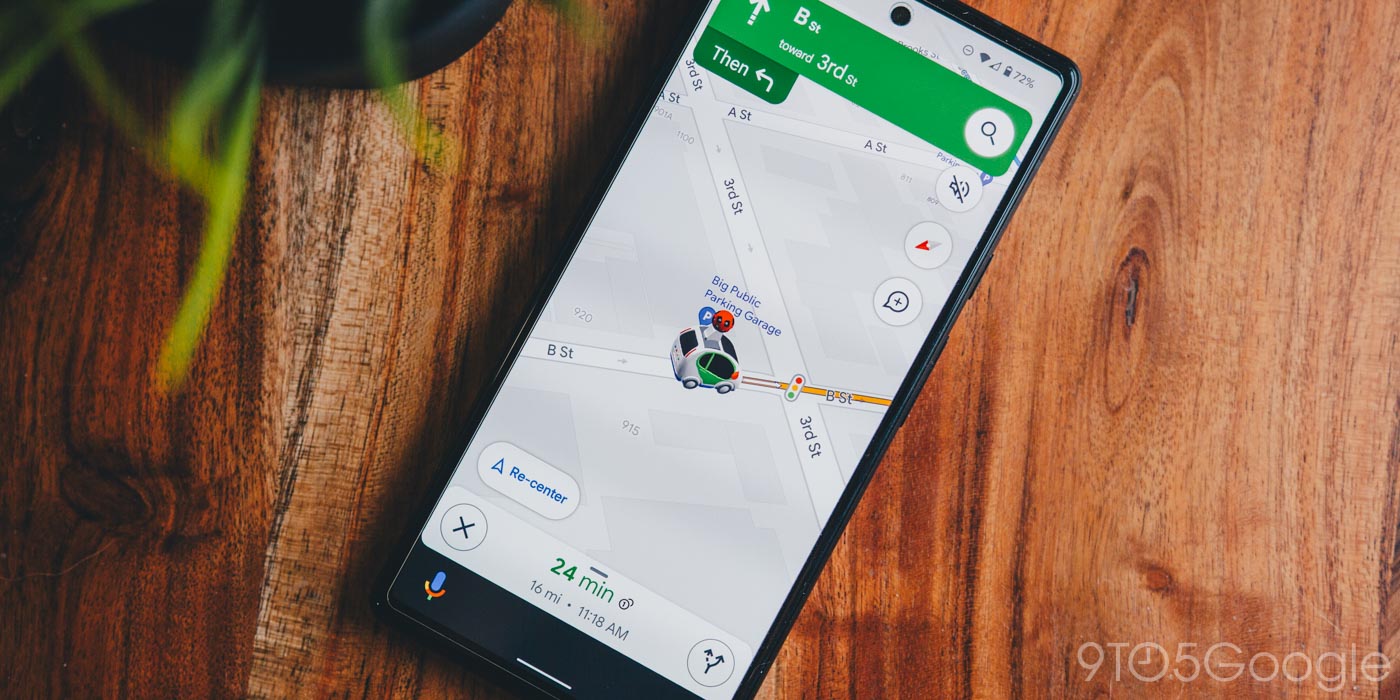
Navigating an unfamiliar city can be difficult, and it can be easy miss a turn even when using apps like Google Maps. An update rolling out today to Google Maps is making it even easier to arrive smoothly at your destination by allowing users to see exactly where to turn and what lane to be in using Street View images…
Similar to Daydream-ready smartphones for virtual reality, Google is launching a certification program for 360-degree cameras. “Street View ready” will insure that the upcoming 20 devices are easy-to-use and that recorded footage meets a standard.

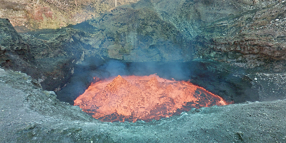
Google’s Street View Trekker system has taken us to some pretty amazing places in the past, but an abseil more than 1,000 feet into the crater of an active volcano has to be the craziest one yet.
We invite you to join us on a journey to the edge of one of the largest boiling lava lakes in the world on the Vanuatuan island of Ambrym. To get inside the active volcano, we partnered with explorers Geoff Mackley and Chris Horsley, who repelled 400 meters into the Marum crater with a Street View Trekker collecting 360-degree imagery of the journey down to the molten lava lake, which is roughly the size of two football fields.
If you prefer to experience your hot air in a more sedate form, Street View has also added a tour of Britain’s Houses of Parliament …
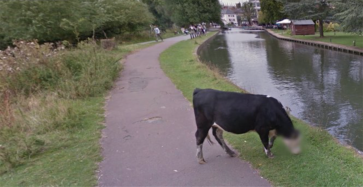
Google Street View is known for the sometimes hilarious moments that it catches, and also for its remarkable ability to recognize human faces and blur them. I guess you might be able to call this case an amusing combination of both. In a screenshot grabbed by one Twitter user, it seems Google has (accidentally, probably) blurred out the face of a cow…
Street View is now a feature we take for granted in all our mapping services, but in 2007 it was a very ambitious effort by Google to photograph the world. The feature on the latest version of Google Maps on Android received a slight revamp to make navigation on mobile easier.