Google Maps for Android

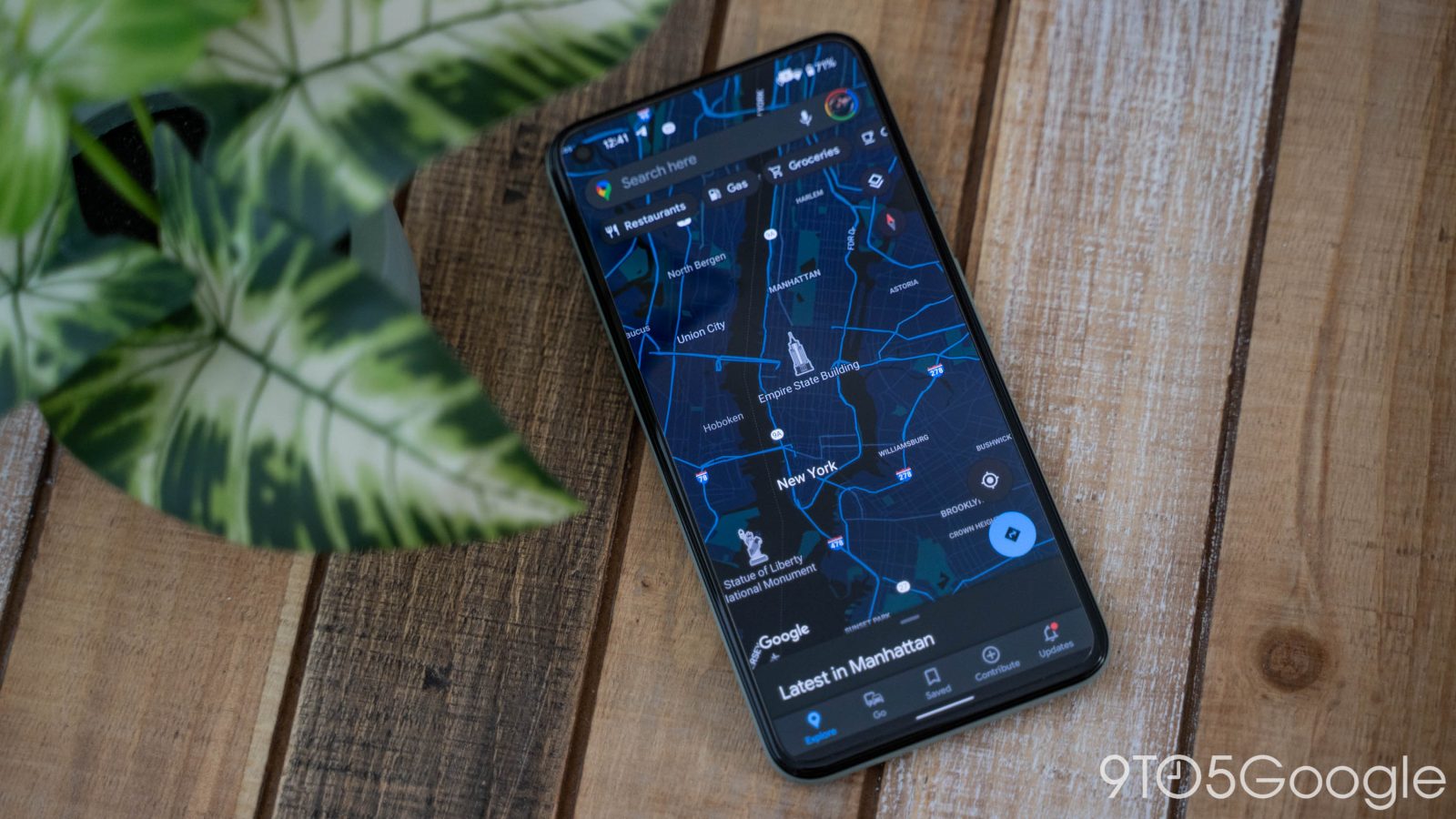
Google Maps has been making a lot of changes recently, including adding expanded support for electric vehicles, letting users see estimated toll prices, and much more. One interesting UI change may have gone unnoticed though. Google Maps has made an adjustment to the shared location user icon.
Expand Expanding Close
Update: Google has officially announced the feature and clarified that Driving Mode will only suggest your home, work, and other recently searched for destinations.
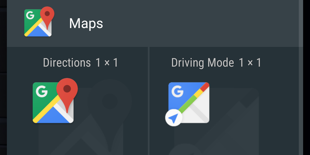
An update to Google Maps for Android adds a new intelligent ‘Driving Mode’ that predicts where you’re heading in order to provide driving updates. Additionally, the update adds more prominent controls for audio feedback and granular privacy settings to the Timeline feature.


Google — Left: Mobile map with all modes of public transit shown; Right: Transit Lines layer in Subway mode
Google Maps now offers schedules for over 1 million public transportation stops in nearly 500 cities worldwide, while its Android counterpart updated today to make the abundance of new transit data more convenient.
Christopher Van Der Westhuizen, a Google Maps software engineer, announced version 6.10 of the Google Maps for Android app on the Official Google Blog:
We’ve made some changes to the Transit Lines layer, so that you can select a specific mode of public transportation (train, bus, tram or subway) to display on the mobile map, hiding the other modes. This is helpful in areas where there is a tight concentration of several types of public transit.
Google offers a list of supported cities at its Transit page.
[youtube=http://www.youtube.com/watch?v=Ujh0_61uYuk&feature=player_embedded]
 Both the Google Earth and Google Maps for Android apps were updated with several new features. Google outlined the new features available in the latest release of Maps on its Lat Long Blog. A couple of the notables include offline maps for more than 150 countries and a new Compass Mode for Street View:
Today we’re also releasing a smoother and faster Compass Mode for Street View within Google Maps for Android. It’s the next best thing to being there, because your device becomes a window into a 360-degree, panoramic view of the outdoor or interior location through Business Photos. To experience the improved qualities of this feature you need a device with Google Maps for Android, Android 3.0 or higher and a gyroscope sensor plus version 1.8.1 of Street View on Google Maps.
As for Google Earth, Engadget noted version 7.0, available on Google Play now, implemented the new 3D tech that Google showed off at its Maps event a few weeks ago.

Google announced today that its live traffic pattern service will now include roads, not just highways.
“Starting today, if you’re planning a trip for which you anticipate traffic, you can find out what typical traffic is like on these arterial roads, rather than just on highways,” explained Google Maps Software Engineer Szabolcs Payrits on the official Google Lat-Long blog.
Drivers can type their starting and ending points into Google Maps to get directions, but they must enable the traffic layer in the upper right-hand corner, and then click “change” in in the legend to view Typical Traffic on regular roads.
")
The Android team announced today in a post over at Google+ that Google’s mapping service on Android won the Best Consumer Mobile Service Award at the Mobile World Congress show in Barcelona, Spain. For mobile users, the Google Maps mobile app, including Google’s other location and mapping offerings, is a reason alone to get an Android handset as many would not be able to get around without it. Though Apple also has a native iOS Maps app that taps into the Google Maps backend, and Google itself provides a surprisingly capable web app, Google Maps for mobile looks and works best on Android smartphones. Perhaps not surprisingly, the latest and greatest Maps features début on Android first. For example: Advanced (and free) turn-by-turn GPS navigation for driving, and walking and public transit directions with 3D views that integrate nicely with Google’s other location-based services like Latitude and Places.
In case you were wondering, the Device Manufacturer of the Year award went to Samsung, which also got the Best Smartphone award for the Galaxy S II. New features in Google’s location-based products are now introducing regularly. The latest update to the Google Maps for Android app brought improved transit navigation and more accurate positioning and indoor maps. Google has a nice interactive overview of Google Maps for newbies here.
Expand
Expanding
Close
")
Photo credit: Lasse Engelbracht on Flickr
Google’s been steadily improving its mapping application for Android and the web. Over the past 30 days, Google updated Maps with ‘My Places’ tab and added offline maps and stop-by-stop public transit navigation to Google Maps for Android. Starting today, the search giant wrote in a blog post, public transport directions are available for the London Underground in both web and Android apps, including all Underground, bus, tram and Docklands Light Railway (DLR) lines:
Let’s say you’re at Trafalgar Square, and you want to visit Madame Tussauds. With a simple directions search, you’ll see all the possible public transport connections. In Maps, click “Get directions” in the left-hand panel, and then the train icon to see public transport directions. Enter your departure location next to A, and your destination next to B. These can be either street addresses or names of popular places, businesses or restaurants. When you’re done, click the “Get directions” button and suggestions for your trip will appear below.
Mobile Maps utilize your phone’s location in order to figure out an optimal rout to your destination, but you’ll also have be presented with multiple alternatives. On Android devices public transport directions are available with Transit Navigation (Beta) in Google Maps, meaning your phone can even alert you when it’s time to get off the tube at your destination.
![]()
![]()
Constant checking of your location is annoying when using public transportation in a foreign city. This will become a thing of the past with the new Google Maps for Android which now features something called Transit Navigation (currently in beta). Basically, this taps Google’s vast mapping database, your phone’s GPS location and real-time public transportation data to figure out where exactly along the route you currently are. The system then alerts you on time when it’s time to hop off the buss, Google explains in a blog post:
Using your location along the route, Transit Navigation will alert you when its time to get off at your destination or to make a transfer. This is particularly helpful if you’re in a city where you don’t speak the language and can’t read the route maps or understand the announcements.
The best bit? It runs in background so you’ll continue receiving progress reports as subtle Android notifications while checking your email or playing a game. It will even vibrate the device when it’s time to get off at next stop. Other improvements include the navigation interface with big icons and built-in picture viewer for Places pages. The new Google Maps 5.7 for Android with Transit Navigation (BETA) can be downloaded now from Android Market on smartphones that run at least Android 2.1. Transit Navigation arrives with support four hundred major cities around the world and Google will probably add more towns in the future.
[youtube=http://www.youtube.com/watch?v=1NTXkd0dguQ]
Expand
Expanding
Close

If you’re unhappy with the underlying information of a business or destination listed in Google Maps for Android, you can now tell Google they’ve got the address wrong – hopefully for future consideration and eventual corrections. It’s the power of the crowd-sourced location data gathering that has gotten Google and Apple in trouble with lawmakers. Another nice-to-have: The app now saves every search query to the cloud so you can access it from another device. The two new features comes in the latest Google Maps for Android version 5.4.0 update.